Wildland Fire Intelligence Products

-
The COTAK team has developed several operational integrations to provide mapping data on current wildfires to wildland firefighters in the COTAK system. These feeds are available to COTAK users on the “CO Wildland Fire MAC” and “CO Wildland Fire Data Feeds” channels, which appear automatically to all COTAK users with a responder type of Wildland Fire, Fire, Emergency Management, or Comm/Dispatch Center. Data sync feeds require the use of the TAK data sync tool, training on which is available for ATAK and iTAK. Specific feeds include:
On the CO Wildland Fire MAC channel:
-
Locations of TAK app users with this channel turned on
-
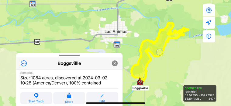
Locations of current wildland fire and prescribed burns in Colorado reported through the Integrated Reporting of Wildland Fire Information (IRWIN) system
-
Data sync feed: Official Fire Perimeters in Colorado reported through the National Incident Feature Service (NIFS)
-
Data sync feed: FireGuard detections in the last 48 hours, in Colorado
-
Data sync feed: Fire perimeters mapped by the Multi-Mission Aircraft (MMA) in the last 48 hours
On the CO Wildland Fire Data Feeds channel (a read-only channel that does not share locations of TAK app users): -
WildCAD incidents in the last 48 hours from the 6 interagency dispatch centers covering Colorado.
-
Lightning strike locations in the last 24 hours in Colorado
-
-
@Brad-Schmidt This is great. It says on itak there is a NIFC arcgis login section. Is this functional? I can not get it to work. If so does it upload more information as in field maps info?? Thanks.
-
Yeah the ArcGIS feature for iTAK let's you view any layer of your choice, it's pretty powerful but does not offer a data capture/upload capability like Field Maps does, it's read only. The feature worked with NIFC AGOL last year, but I just checked and it's broken for me too. I suspect that has to do with the 2 factor auth requirement that they added this year, but I'll ask the iTAK developers to look into it. In the meantime if there are other ArcGIS layers that you'd like to see in TAK just let me know and I'll see if we can integrate them similar to our existing fire channels.